Andhra Pradesh · all 26 districts

Every survey number in Andhra Pradesh, on one map.

Open the satellite map, tap a field and see its survey number, boundary, village, mandal and area in seconds. Measure plots before you buy, and download a print-ready map of a whole village.

  • Free to search and measure
  • New 26-district names
  • Telugu & English
AP LandGrid showing survey number boundaries over farmland
40 lakh+survey numbers
26districts, new boundaries
Allmandals & villages
Freeto search & measure

What you can do

Built for buyers, farmers and surveyors in AP

Four tools, one map. Everything below works on any village in the state.

01

Find the survey number of any field in Andhra Pradesh

Zoom into your village and survey numbers appear on top of high-resolution satellite imagery. Search by village or mandal, or use GPS to start right where you stand.

  • Boundaries drawn over the real ground
  • Search any village by name
AP LandGrid map opening on Vijayawada
02

See the details of a parcel

Tap any parcel to open its card: survey number, village, mandal, district and the area worked out from its boundary, in acres and square yards. Save it, share it, or set an alert.

  • District names follow the 2022 reorganisation
  • Share a parcel link with family or a broker
Survey number 303 details card
03

Measure land before you visit

Tap the corners of a plot to get its area and perimeter, or draw a line or path to check a frontage or a road length. Save measurements and come back to them later.

  • Line, path and polygon tools
  • Every side length labelled on the map
Measuring a field polygon with side lengths, area and perimeter
04

Download any AP village map as a PDF

Pick a district, mandal and village to get one printable map with every survey number in it. Preview a free sample first and see the price before you pay.

Buy a village map online
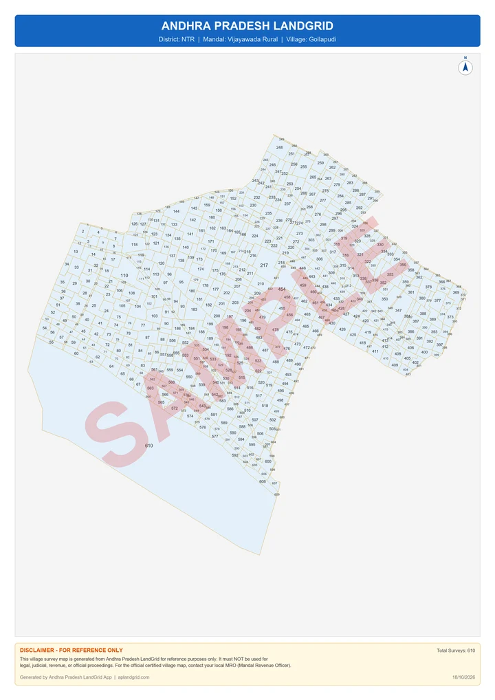
Sample village survey map PDF of Gollapudi, Vijayawada Rural, NTR district

Coverage

All 26 districts of Andhra Pradesh

Parcels are grouped under the new district names. Pick a district to see its villages and order a village map.

Reserve forests (Nallamala, Seshachalam and the Eastern Ghats agency hills), lakes such as Pulicat, river beds and many town areas are not part of the rural revenue survey, so no parcels are shown there.

Sample village survey map of Gollapudi, Vijayawada Rural mandal, NTR district,

Village Survey Map · PDF

Your AP village on one printable sheet

Every survey number and boundary of the village on a high-resolution A3 PDF. You see the survey count and the price before paying, and the map arrives on screen and in your email.

₹600up to 250 survey nos.
₹1,200251 – 500
₹1,800501 – 1,000
₹2,4001,001 – 2,000
₹3,000above 2,000

Sample shown: Gollapudi, Vijayawada Rural, NTR district. For reference only, not a legal document.

Three steps

Find an Andhra Pradesh survey number in three steps

  1. 1

    Install AP LandGrid

    Free on Google Play. No account needed to explore the map.

  2. 2

    Go to the land

    Type a village or mandal name, enter coordinates, or tap the GPS button when you are on site.

  3. 3

    Tap the parcel

    Its survey number, location and area appear instantly. Measure, save or share it from the same card.

FAQ

AP land survey questions people ask us

Something else? Write to [email protected].

Is AP LandGrid free to use?

Yes. Searching the map, viewing survey numbers, boundaries and area, and measuring land are free. Only the full village survey map PDF is a one-time paid download.

Which parts of Andhra Pradesh are covered?

All 26 districts of Andhra Pradesh, grouped under the new district names.

Is this official government land data?

No. AP LandGrid is an independent app and is not affiliated with the Government of Andhra Pradesh. It shows publicly available survey boundaries for reference. For official records such as Adangal or 1-B, use the government Meebhoomi portal or visit your Mandal Revenue Office.

Why are there no survey numbers in some areas?

Reserve forests such as Nallamala and Seshachalam, lakes like Pulicat, river beds and many town areas are not part of the rural revenue survey, so no parcels are shown there.

Does the app show the land owner's name?

No. It shows the survey number, boundary, area, village, mandal and district only. Ownership details are available only from official revenue records.

How accurate is the area?

The area is calculated from the mapped boundary of the parcel. It is a close guide, but it can differ from the extent recorded in revenue records, so always confirm with official documents before a transaction.

Check Andhra Pradesh land before you sign.

Download AP LandGrid and look up any survey number in Andhra Pradesh in seconds.